History of the Ottawa Lebreton Flats Area
There is much to be said about connecting with the past, and what better subject in Ottawa than a mode of transport that was so important to Indigenous people over thousands of years and adopted(at least the canoe and kayak) more recently by other cultures who have made this country their home. So this area of the ORR website includes topics that are connected (boats, paddles, neighbourhood) to the the old Pumping Station whose outflow we rely on or the flatwater course beside Victoria Island.
For other interesting information on Ottawa history visit: www.bytown.net/
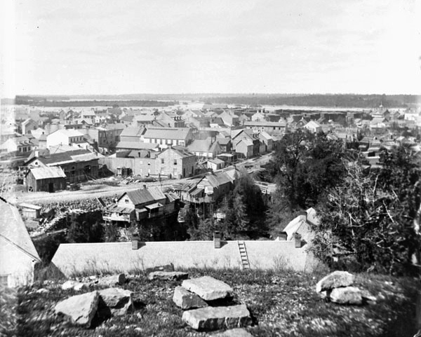
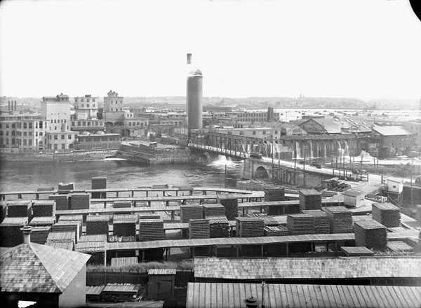
Here is a view of the Chaudiere Falls and the surrounding (Chaudiere) area, close to what is called LeBreton Flats. You can see Victoria Island, stacks of lumber, and a street running along the cliff top where the Supreme Court and other Federal buildings now sit.
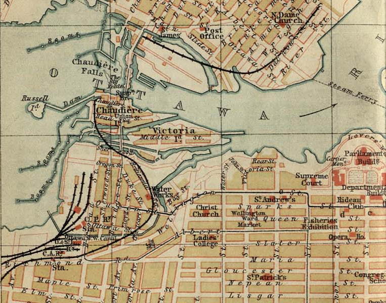
Ottawa Map 1894
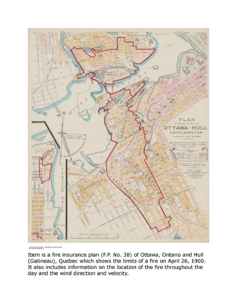
Here is a segment of a map dated 1894 of Ottawa, showing the area around the Ottawa Pumping station or “Water Works” where our whitewater course is located today. It is apparent that with the levelling of the area in the 1960’s, that many streets and names disappeared. On April 19 1962, the 2,800 odd residents and property owners of the LeBreton Flats received a notice of expropriation, which started a deconstruction ending with the tear-down of the last building torn in 1965. The intention was to get rid of this area ‘eyesore” so close to the Parliament Buildings and downtown area, however it laid dormant basically until after 2005 when the new War Museum was built and condo development started. Needless to say, those that were displaced lost a home , possibly a job and a neighbourhood and then watched as nothing happened for years.
Other things to note include Booth’s rail line, built to move lumber out to U.S. markets, and the timber slide channel south of Victoria Island, of which you can see a photo in the lumbering section.
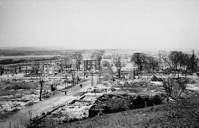
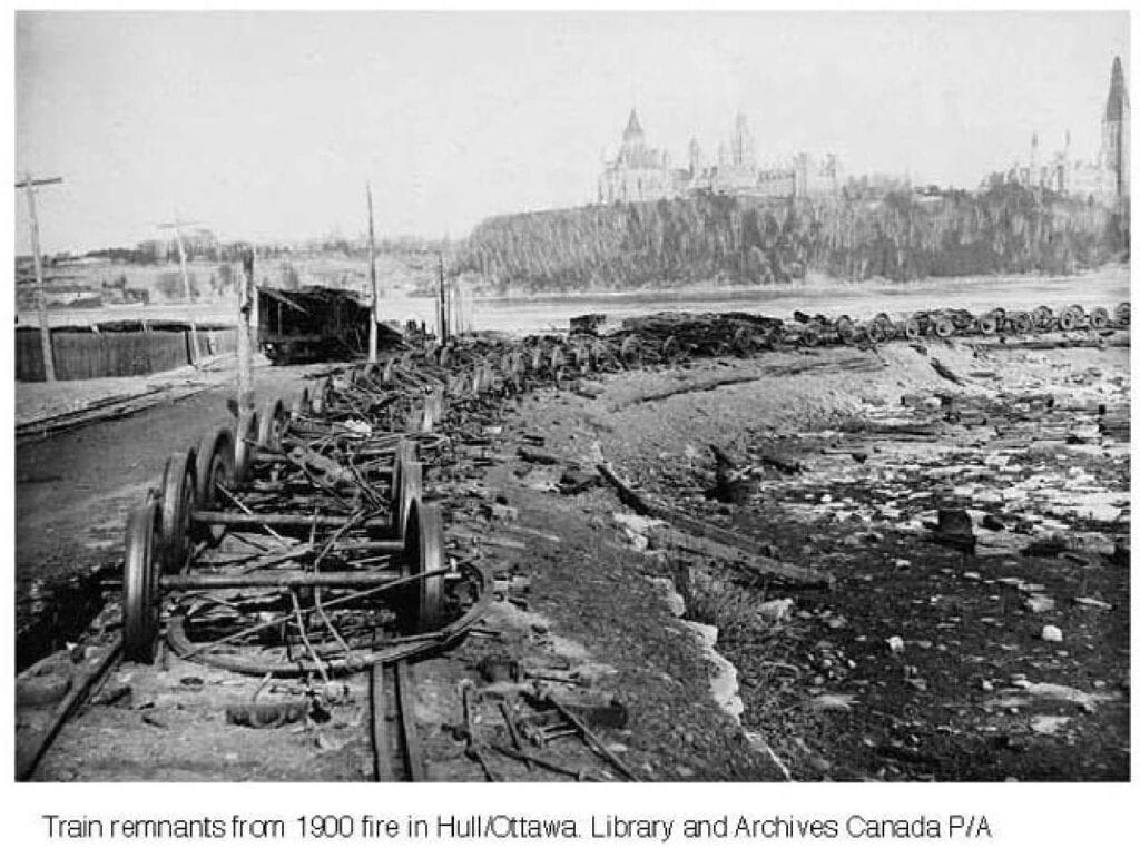
Below is how Ottawa looked, from south of LeBreton Flats, looking North towards the Gatineau Hills after the fire of 1900, which burned 40% of Hull and 20% of Ottawa. Hintonburg was spared due to the rail line firebreak The fire started in Hull and spread to Ottawa via the wooden bridge spanning the Chaudiere Falls. Reconstruction of many homes subsequently used brick over their wooden frames. The Parliament buildings were destroyed by fire later in 1916. Seven people died in the fire and 15,000 made homeless.
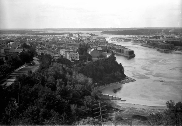
Ottawa River Panorama 1920
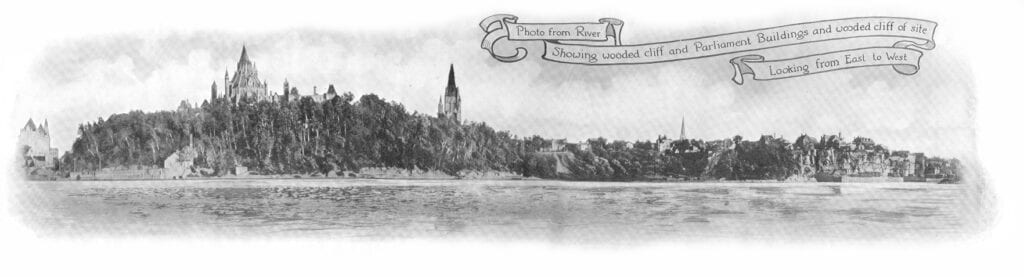
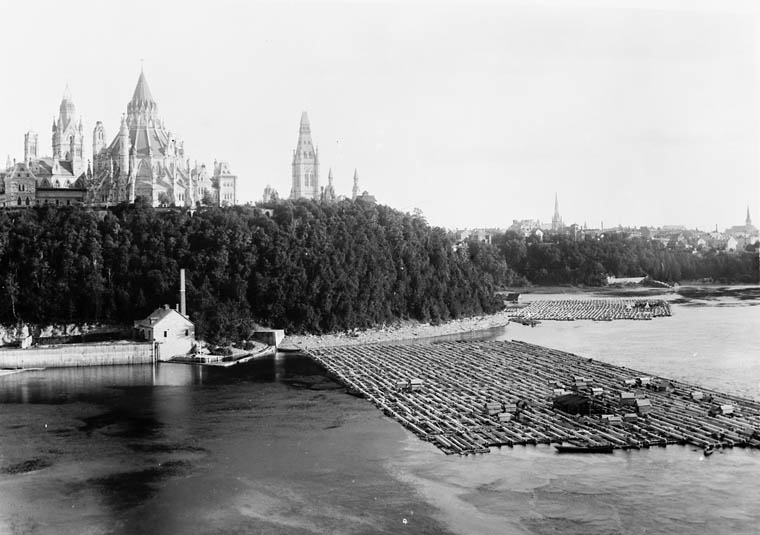
This photograph was taken about 1920, picked up at an antique dealer in Ottawa. It shows the recently built Chateau Laurier Hotel far left, the almost complete Parliament Buildings(Peace Tower not yet complete), the West Block Tower, St-Andrews Spire further west and houses on the bluff where the Supreme Court currently sits. Further right you can see lumber stacked as you near LeBreton flats, and of course the current flatwate section of our pumphouse course. The Parliament Buildings (apart from the conical Library) burnt in the great fire of 1916 and was rebuilt in a new style, with taller central Tower.
Chaudiere or LeBreton Flats Area
The Ottawa-Gatineau area in 1826 was actually a settlement of about 800 people working primarily in agriculture and lumbering located on the Quebec side of the river. By 1828, in anticipation of canal construction, a settlement of about 1,000 people existed on the Ontario side. The city of Bytown would be incorporated as a town in 1847 and in 1855 was given city status with a new name, Ottawa.
Ottawa has always been connected to the river. The LeBreton Flats area, adjacent to our Pumphouse whitewater facility consisted of massive lumberyards, housing, hotels, storage for coal, railyards etc. In fact it blended into an area known as Chaudiere, encompassing the Chaudiere and Victoria Islands. The Chaudiere name was from the proximity to the Chaudiere Falls, which unfortunately is not as spectacular as it once was due to the power generating dam. The original intention (of Lord Dalhousie) back in 1820 was to have Colonel John By build the Rideau Canal from Dow’s Lake to Chaudiere Falls across what was to become LeBreton Flats area. Apparently Captain John LeBreton purchased the land from under Dalhousie’s nose, speculating it’s value would rise. Dalhousie was miffed and changed the plans to have the canal exit between Parliament and the Chateau Laurier(property he owned). LeBreton Flats takes its name after the wily but unsuccessful Captain. Also of interest, is that ill fated Arctic explorer Sir John Franklin, laid the first stone of the Rideau Canal locks in 1827, with the man made waterway completed in 1832. Many labourers contracted malaria and died during the construction through some of the swampier areas between Ottawa and Kingston.
The following are pictures from the National Archives web that show a marked contrast to today’s network of bike paths, museum, condos, and of course whitewater paddling area.
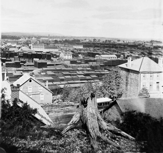
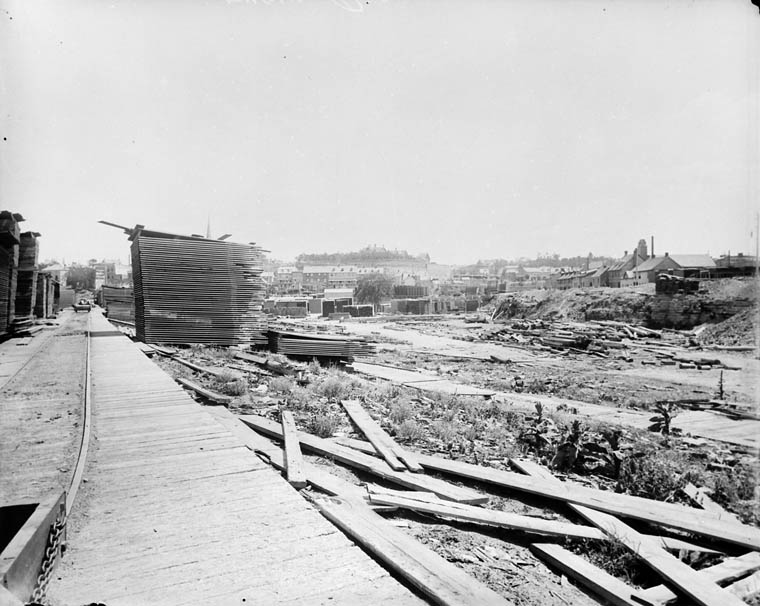
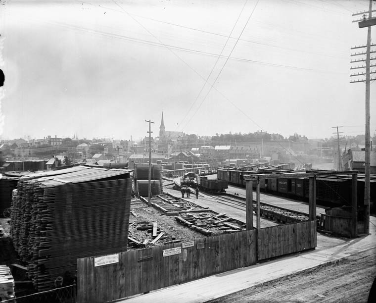
View of LeBreton Flats and Chaudiere from Bronson hill and Christchurch Cathedral area, though it is difficult to see the pumping station clearly in the jumble of houses and factories which transition to the lumber storage areas.
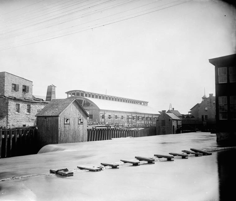
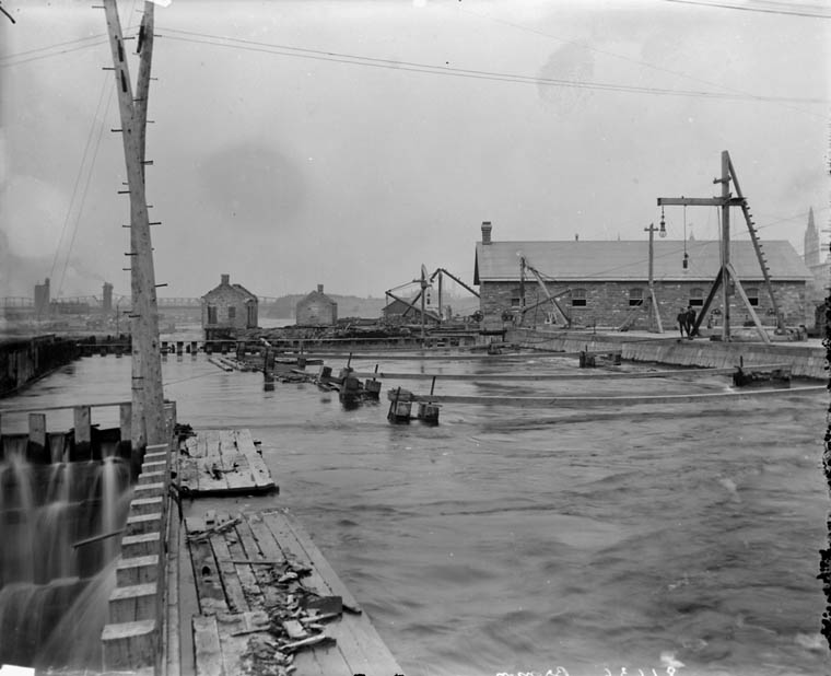
The view below appears that it could be the outflow channel from the pumphouse, with buildings perched on stilts along the road on the west side. The Ottawa Map 1894 earlier on this page appears to validate this.
From the waterside the area looks a bit more industrial, and there is no surprise why there has had to be much contaminated soil removed recently as the NCC and City of Ottawa have move to fix up this area, primarily after 2000.
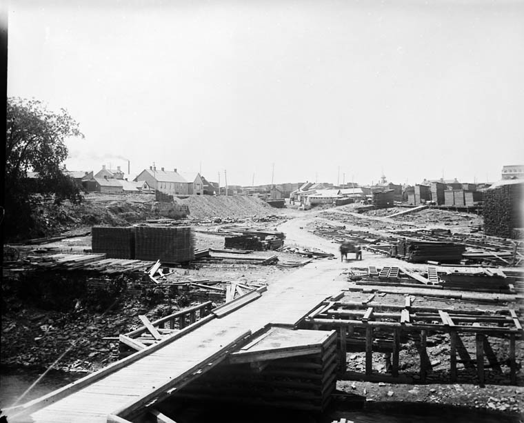
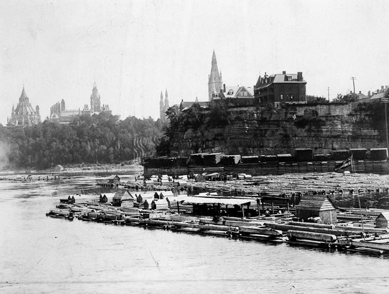
This is a view from the LeBreton/Chaudiere area looking South East ( It appears that Christ Church Cathedral may be the spire behind the stack of lumber in the foreground)
Here is view from the same area – near the waterside, but looking Southwest across the neighbourhood. It is not clear what this channel is – perhaps outflow from the existing Pumping Station?
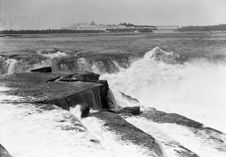
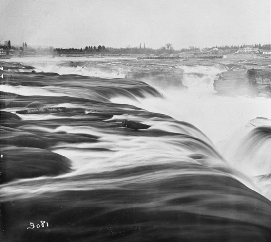
The Chaudiere Falls
The Chaudiere Falls was a natural meeting place for thousands of years. A key portage on the Ottawa River for natives and voyageurs, it also provided the spark for locating the lumbering industry in Ottawa, with its potential power for saw mills. Although not the first European to pass through here, explorer Samuel de Champlain portaged the falls in 1613 on his way up the Ottawa. (His astrolab was discovered further up the Ottawa in recent years)
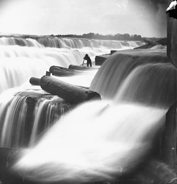
The following views were taken prior to 1900 of the Chaudiere Falls in Ottawa. This was before major power dam construction. The first shot obviously taken before high speed camera shutters were developed, but gives a soft surreal view of what must of been accompanied by a deafening thunder of water.
The following shot shows an old steam engine crossing the Lemieux Island bridge to Hull.
Quite a narrow gorge! Not an easy paddle…
Not the sort of log jam you would want to venture out on….
Victoria Island, Ottawa
Victoria Island is adjacent to Chaudiere Falls, and during the late 1800’s into the 1900’s became an industrial eyesore as much of the area around the Ottawa River here. It is actually an historic portage trail that was used for centuries by natives and voyageurs as a means of getting by the great waterfalls. As such it served as a sacred place to meet and trade. It more recently has been utilized in the spirit of its past, at least on the east side where Aboriginal Experiences have set up a Native village with dancing and other activities. There are still remnants of industry elsewhere, with the potential to became a more engaging part of the river for the public, with some vision.
Here are 2 photos prior to 1900, showing some industrial buildings on Victoria Island.
The Squared Timber Trade
The first timber raft left on its way to Quebec city in 1806 guided by Philemon Wright, his sons and other crew.
Huge rafts of squared timber were floated down the Ottawa River from far upstream, navigating around falls and rapids by means of timber slides. The first areas cleared were of course for farming in the Ottawa valley, producing hardwood and softwood. White pine was the major export, and initially one of the main customers for the virgin growth was the British Navy, who prized these massive straight, strong trees as masts.(the oldest trees were up to 230 feet tall) There are cross sections of white pine taken in Algonquin Park that are 500 years old. Due to logging and pulp and paper, there is little chance of seeing any of these monsters for some time. One of the prime lumbermen in Ottawa was J.R.Booth.
Here some pre-1900 views of the rafts at Ottawa.
The last raft of the season, 1870’s. Note the tents, cooking facilities on board…and the lumber stored where the bike path exists today. This is before government buildings displaced large homes on the bluff in the foreground.
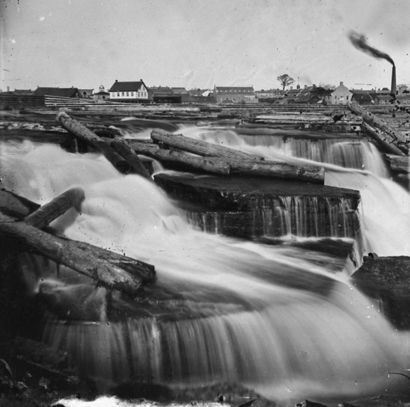
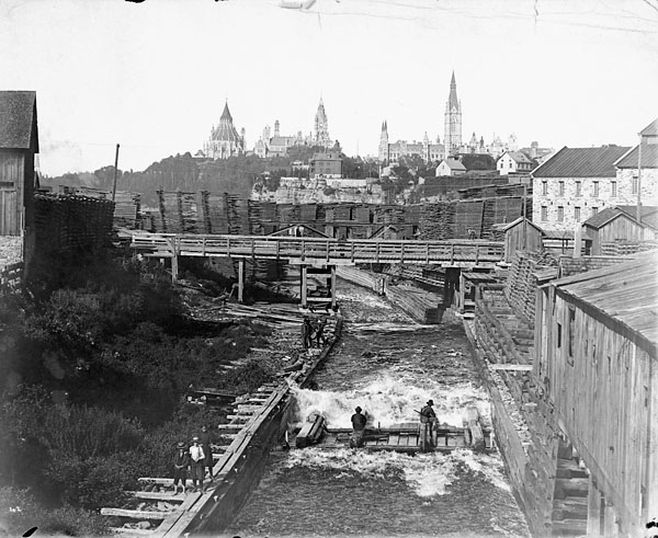
The timber slide on the south side of the Chaudiere Falls close to Victoria Island is shown below. (there was also a slide built in 1829 on the Quebec side) Note the tower of the West Block of the parliament buildings actually looks taller than the main block tower. Of course this is pre-fire of 1900 when the main parliament buildings (except for the conical Library) burnt down as well as much of the (wood) homes in the city. The slide was built in 1832 by John Buchanon taken over by the goverment in 1845 when the lease was revoked. In 1850 300-500 cribs passed down the slide per day. In 1860 the Prince of Wales was given a ride down the slide along with other dignitaries. For more photos of lumbering in the 1800’s and description of life in the bush, refer to the Bytown Museum site:
https://bytownmuseum.com/news/trees-root-ottawas-economy-les-arbres-fondement-de-leconomie-dottawa/
More Chaudiere Industry
J.R. Booth, a carpenter born in Quebec’s eastern townships, moved to Ottawa in 1854 where he built a sawmill near the Chaudiere Falls as well as some of the area’s bridges. His big break came when he was awarded the contract to supply timber for the new Parliament Buildings in Ottawa(built 1859 to 1866). In 1867 he purchased 250 acres of prime virgin white pine in what is today Algonquin Park for a mere $45,000. His timber limits ultimately covered much of the upper Ottawa River. In 1890 he established the Canada Atlantic Railway to transport lumber from his mill Ottawa to the U.S.A. Apparently he also built a railway bridge across the St. Lawrence River to move his lumber faster than if he had relied on barges. By 1892 he was the largest lumber producer in the world. (ref. Ottawa Public Library)
E.B.Eddy was born in Vermont. He came to Hull (across the river from Ottawa) in 1854, where he started producing matches from discarded wood from local sawmills. He expanded into wood products(wooden pails, clothes pins, sash and doors, boxes) and pulp and paper (first paper machine installed 1890) Later he also became a political figure in provincial and municipal government.
Henry Bronson was another American who came to Canada looking to find new sources of timber. He set up a mill at the Chaudiere falls in 1852. He secured timber rights on the Gatineau, Dumoine and Madawaska Rivers. Much of the lumber was exported to the Northeastern U.S. His son Erskine Henry carried on with the business until 1899 when it became a holding company called “The Bronson Company” .
Here is a picture of the J.R. Booth facilities as seen from E.B.Eddy buildings in Hull pre-1900.
The following photo is from Booth’s Canada Atlantic Railyards at the western end of LeBreton Flats. Christ Church cathedral can be seen in the background.
The following is a view from the Bronson Company looking east along the river toward Parliament Hill.
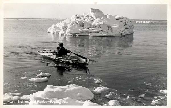
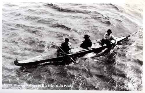
Single Ended Paddles
If one looks carefully at C1 and C2 slalom canoe/kayak racing, (come to the Pumphouse if you want to see these boats in action) you are struck by how different the boats and paddles are from more traditional Native or Inuit ones.
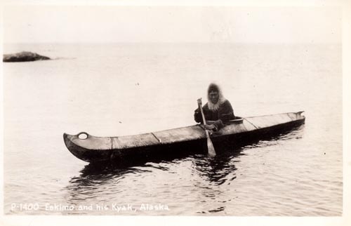
For example a slalom whitewater C1 boat appears to be a recent development – you take a kayak, because it is sleek and keeps water out – but instead of sitting, you kneel and use a single blade paddle like a canoe. To one’s surprise this has been around for perhaps thousands of years, not as a means of managing whitewater, but for other reasons. The Inuit of the western arctic, Alaska and Siberia utilized a single ended paddle for manoevring in tight spaces in pack ice, and also as a means of more stealthily approaching game. A double bladed paddle provides a more obvious signal that the hunter is approaching than a single blade would. These Inuit paddlers also kneeled in their boats, which was called a “baidarka” in Russian. Here are some pictures from Harvey Golden’s amazing pages on Traditional Kayaks.
Links:
www.tuktupaddles.com/index.html
www.arctickayaks.com/paddles.htm
Paddles
Paddles have developed in countless forms around the globe for many reasons; flatwater vs. whitewater, shallow vs. deep water, boat size and shape, need for combined weapon and paddle, recognition of tribes …. The narrower voyageur paddles shown below by virtue of their more gradual entry and exit and lighter force on the arms allowed long days of paddling for example.
There is something about making a paddle by hand out of wood that provides a sense of satisfaction and appreciation for the skill of those in the past who used much more basic tools than we do now. For a great overview of paddle types I recommend you visit Murat’s site listed below. He has added some beautiful decoration of his own to some designs and applied traditional native colouring to many types of paddles he has built. Make sure you take a look at the variety of paddle and paddlemaking topics along the right hand side of his webpage.

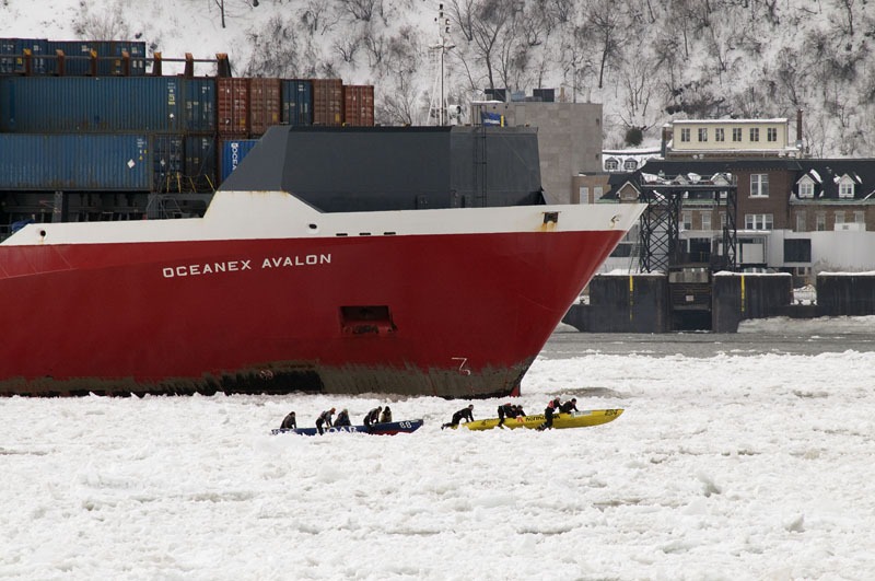
Ice Canoe Racing – A Quebec Tradition
Now for something that has some history to in and is truly Canadian. The first is a shot courtesy of celebrate canada website, showing ice canoe racing in Quebec City.,,and we thought racing amonst ice encrusted shoreline at the pumphouse was cold! Apparently the big ships just cruise on by and the canoeists just have to manoevre around them.
Apparently this concept began as a real competition between families in small wooden postal boats in the early 1900’s. (Before a bridge was constructed to join Quebec City and Levis) The fastest teams would win the right to deliver the mail. Approximately 40 teams struggle to win during the Quebec Carnival in February each year.
celebratecanada.wordpress.com/category/sporting-events/
race.fit2paddle.com/C2047168441/E20070131131733/index.html